Trekking the Tarns
After a few dramas travelling from Plovdiv to the small town of Sapareva Banya, I was pleased to plonk my bags down in my accommodation for the night. Plovdiv to Sapareva Banya isn’t so far as the Bulgarian hooded crow flies, however the direct bus I had planned to catch turned out not to exist, so it was a two train and one bus dogleg via Sofia instead. I arrived just on dusk, and was a little worn out, though excited about the three day hike I was going to do in the Rila National Park. The Park is home to one of the most famous and popular hikes in Bulgaria, the ‘Seven Rila Lakes’. After grabbing a feed, I set aside my camping gear and tucker I was going to need for the trip, then flopped into bed.
Next morning, having left the remainder of my gear in the storage room at the guesthouse, I walked out to the street where several tourist transfer minibuses were parked up. An older bloke soon approached and asked me if I needed a lift to up to Rila Lakes. I said I did, we agreed on a price, and away we went up the 17km road to the base of the chairlift that takes visitors up the final 515m elevation to the National Park. My driver spoke very little English, and with my Bulgarian vocabulary being only three words (‘da’ meaning yes, and interestingly ‘merci’ for thankyou and ‘ciao’ for see ya – come to think of it, you could argue I didn’t know any Bulgarian words at all), our conversation was a bit stunted. Still, we managed a little communication and a few laughs during the journey. After reaching the top, my driver gave me his number, and instructions in Bulgarian that I took to mean ‘call me when you need a lift back mate’.
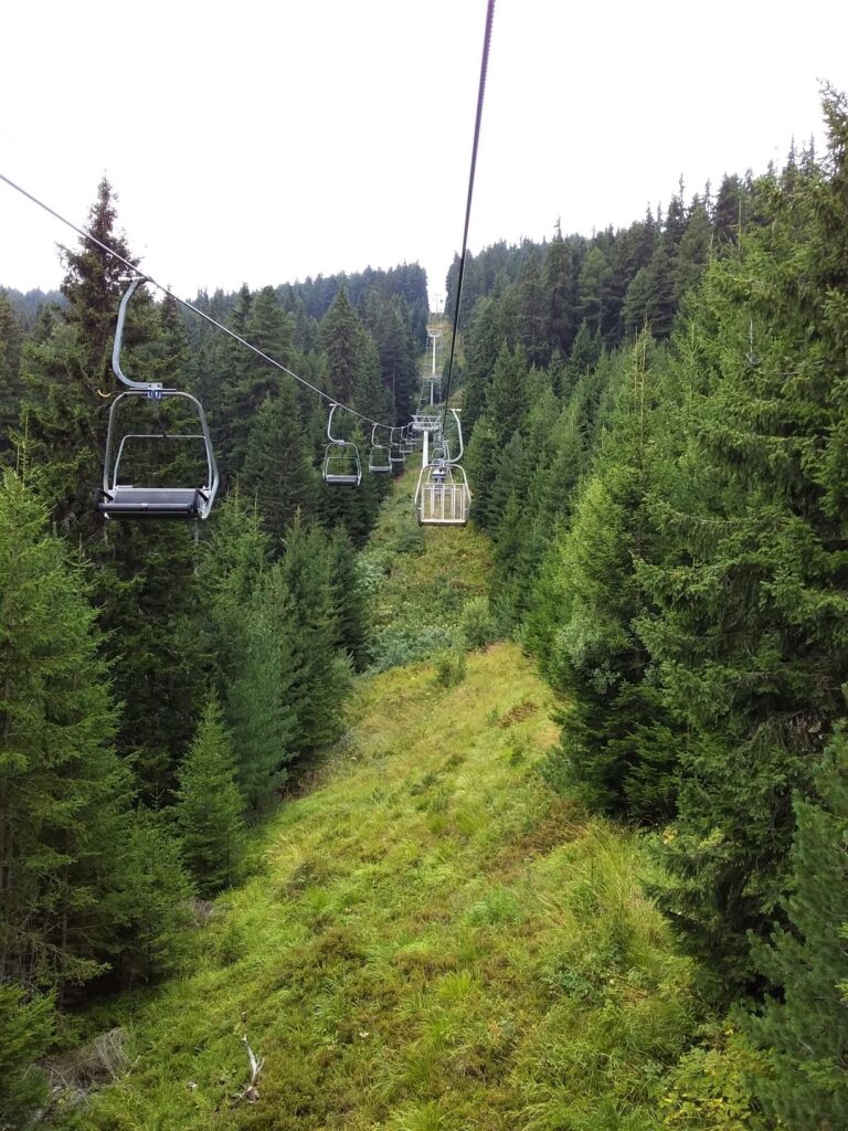
The mountain air was noticeably colder than down in the town, and not for the last time that day I wondered if my gear was going to be warm enough for the two nights I planned to camp out. I walked the short distance to the chairlift office, and after stumping up my 20 lev (about AUD 16.50) I had a return ticket to ride. I don’t think you’re ever too old to enjoy a ride on a chairlift, and after sitting down on the still moving seat I swung away with a lurch, dropped the safety bar, and sat back for the around 20 minute trip to the top.
Chairlifts are ace
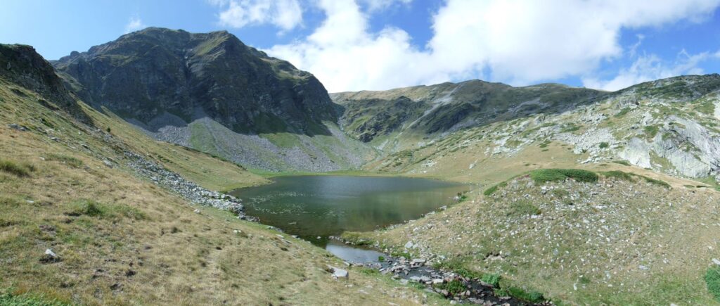
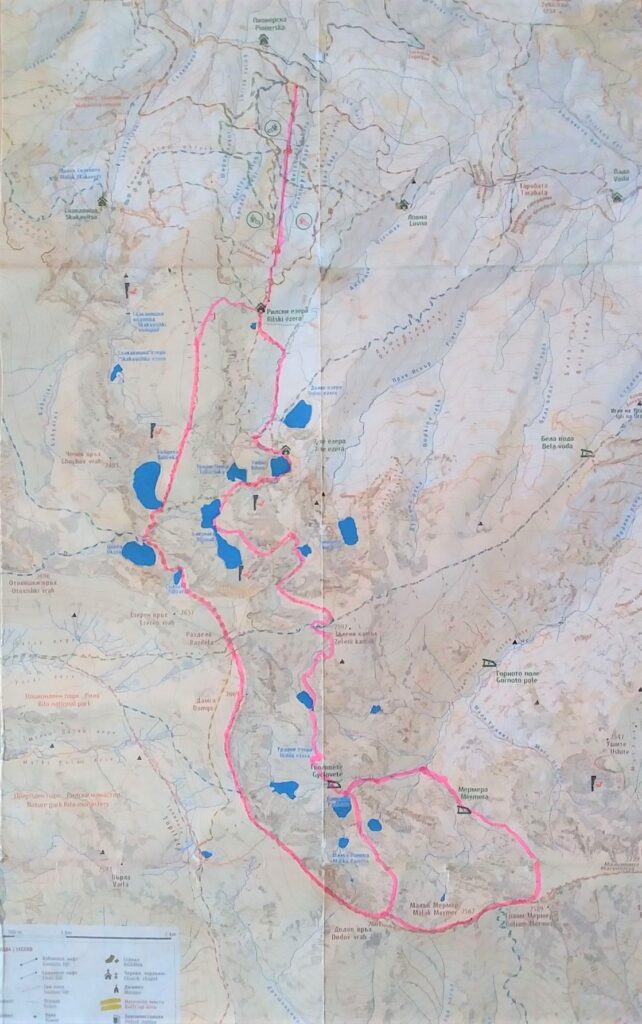
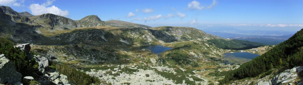
The Seven Rila Lakes walk, which takes about 5 hours, starts at the Rila Lakes Chalet at the top of the chairlift. There were people of all ages and stages making their way up the initial climb, some powering along, others taking it easy and some wheezing hard. I was visiting mid-week, and although the walk was busy, it certainly didn’t detract from the experience. I reached the first of the Lakes, named ‘The Kidney’, which was perched just below the clouds.
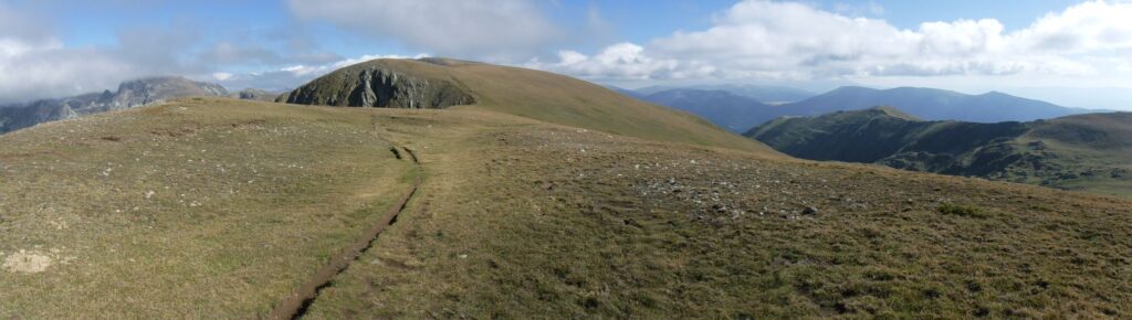
The landscape of Rila National Park is dotted with ancient glacial lakes
It appears that the information signage at Rila National Park had been designed by new-age rangers.
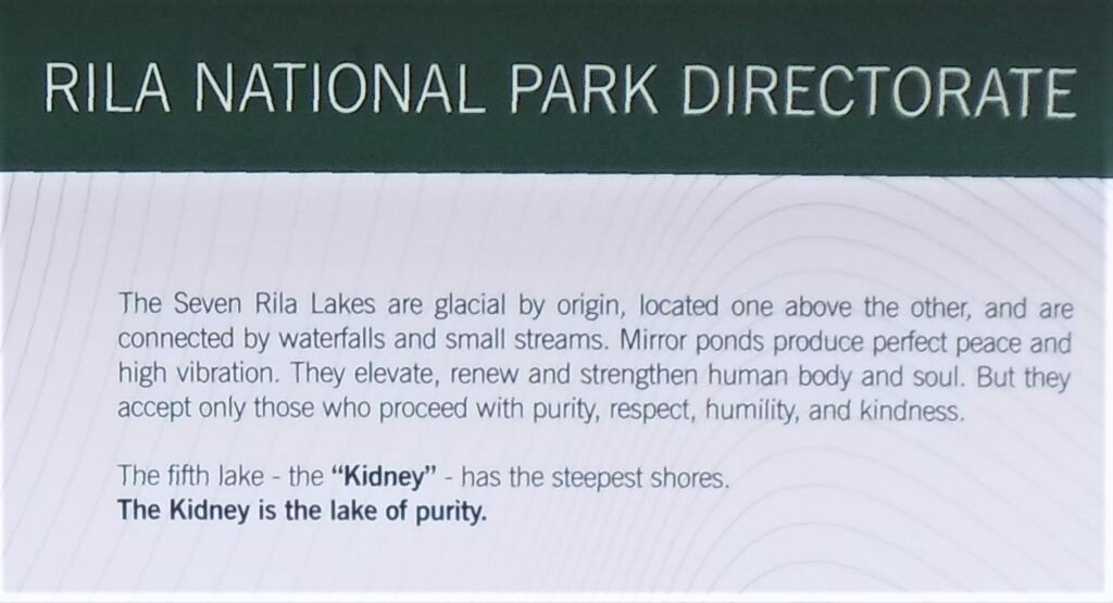
Still, I was open to having my body and soul elevated, renewed and strengthened. However it did leave me wondering what happens to those that are not accepted by the Lakes, having proceeded without the necessary purity, respect, humility and kindness…
I had picked a day of misty low cloud, and as I climbed higher the visibility obscured the views and the famous lakes.
I reached the point where the Seven Rila Lakes loop heads west to eventually return to the Chalet, and keen to add some more distance to my walk, continued to the north. Thankfully the cloud broke up over the ranges on a north-easterly wind, and I found myself alone on the spur.
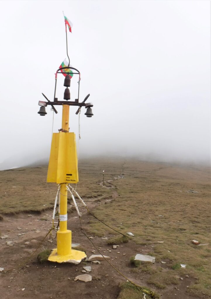
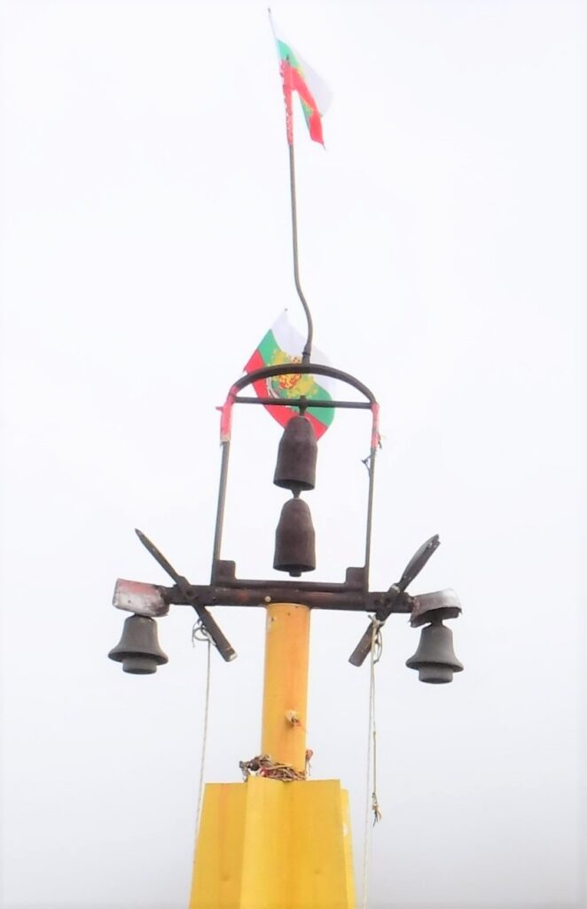
This particular track was marked with poles, designed to assist navigation during the snowbound months. I also came across this marker at a fork in the track. Those are a couple of cow bells above the centre of the pole, which presumably sound in heavy wind and help you to locate the track intersection. When connected up, I assume you use the ropes and swinging arms to ring the bells at the sides if required to attract attention to your plight.
In the chilly late afternoon I set up camp, and was tucked up soon after the sun disappeared behind the ranges to the west. I could hear the hollow clunking of ‘cow’ bells in the distance, used by locals to keep track of their horses which graze the alpine grasslands in the summer.
The slight slope where I had pitched my tarp and placed my bivvy bag turned out to be a little steeper than I had thought. I woke up sometime during the night having slid down the dewy grass and out the end of the tarp, with only my head still under cover. I wriggled like a catepillar back up the slope and under the tarp, and spent the rest of the night with my feet braced against a couple of rocks to avoid sliding down the mountain and waking up in the creek several hundred metres below.
There was frost on my tarp and bivvy bag in the morning, and despite a clear sunny sky, I set off still wearing a thermal top and jacket. I had picked up a topographic map of the mountains, upon which the major and minor walking routes were marked. However I was unable to find the track I had planned to take, so did a cross-country cut to a distant spur and picked up an alternate route.
I was definitely on the road less travelled, and the track appeared and disappeared as I worked my way around to the north. It was steep country, and I was spoilt for choice of beautiful places to take a breather.
I pulled up mid-afternoon at the camp site, determined to find a flat spot to avoid a repeat of the previous night’s bivvy bag tobogganing. I found a spot protected from the wind and set up. It was cooling down fast, and once again I was tucked up early and hoping for a better night’s sleep.
I woke at some stage during the night to the flapping of the tarp. The wind had swung around 180 degrees, from a light breeze to a katabatic wind rolling down the mountains. It came in waves; I could hear it rushing towards me in the distance, then it would attempt to tear my tarp apart and blow it to Romania, then pass and a calm would return. The wind blew out one of my tarp guy ropes, so there was nothing for it but to get up and pull the remainder of the tarp down. Having managed this in between the gusts I climbed back in to the bivvy, but after more pummeling from the wind I was up again soon after to shift the whole camp. I found a more protected spot, and thoroughly cold from being out in the freezing night air, climbed back inside my sleeping bag hoping for some undisturbed sleep.
I must have banked a few hours as the sun was over the horizon when I woke. After packing up the camp, and a breakfast of muesli and powdered milk, I started off on my way back to the Chalet. I had a pretty steep climb first up, and came upon a mob of horses near the top. I had seen them in the distance the previous evening, and had heard the clunking of the bells they carried. They were in good nick from the lush pasture, and several of the mares were in foal.
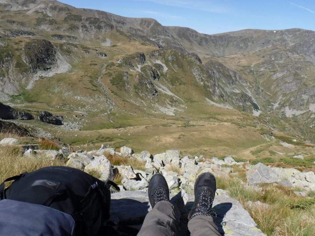
After having discovered some of the tracks marked on the map no longer appeared to exist on the ground, I was wondering if I would be able to follow the route I had chosen for my final day. At one stage I climbed a steep, pointed, solitary peak in order to link up with a track that would take me to Twin Lake. Although the path wasn’t there, I did get some breath-taking views from the top of the peak.
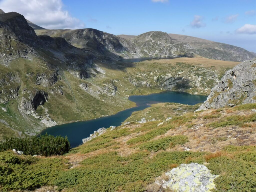
By early afternoon I had linked up again with the main Seven Rila Lakes circuit. I always feel a little overwhelmed when, after a couple of days out walking and hardly seeing a soul, I find myself back amongst people. Continuing my gradual descent, I made my way past the final three lakes, Trefoil, Fish and Lower, and onwards towards the Chalet.
I was ravenous by the time I reached the chalet, and over the last few hundred metres I picked up the delicious aroma of barbequed food. Quickening my pace, I followed the track and my nose through the trees and arrived at the back of the chalet, where a food stall and grill had been set up. After eating repetitious, bland meals for the past few days, I gleefully sat down to a plate of BBQ goodies and fresh bread amongst the crowd of returned hikers. It was a perfect way to end what had been a very enjoyable trek through the Rila Seven Lakes. The country is spectacular, and being only about 1.5 hours from the capital Sofia, I can understand why it is one of the most popular walks in Bulgaria.
For more on Rila National Park click here
If you liked this post, you may also enjoy Climbing La Concha, Hiking the Dry Stone Route
Leave a Reply